Monday, May 10, 2021

Homeward Bound, Lyttelton to Kawau Island

 We are now in get-home mode. Sitting on a friend’s mooring in Bon Accord harbor on Kawau Island, we can smell the barn. This is our backyard; it’s in the Hauraki Gulf only forty miles from Whangarei harbor, and we’ve been here many times. The mooring is owned by Ric and Kitty Martini, a couple of ex-pat Americans and dear friends we have known since we first arrived in New Zealand in 2004. The wind is out of the north today and tomorrow, which would be against us, so we’re biding our time waiting for a change to finish that last leg. If the forecast holds true — it actually does on occasion — we’ll have another romping downwind run the day after tomorrow.

These few days here are turning out to be pretty socially active. As I write this, today is Tuesday. We came over from Tryphena on Great Barrier Island on Sunday — I’ll get back to that. Yesterday, some yachtie friends, Lin and David, that live here on Kawau, had us over for dinner. Also there was Alana, a young American woman solo-sailer (another covid-refugee) that has just completed a figure-eight circumnavigation of NZ over the summer, fundraising for a charity serving foster children. We had seen flyers for her project and talks at various places this summer, but had not been at any of them. Lin is a bit of a mover and shaker, so it wasn’t that surprising to encounter Alana there. Two German yachtie friends (also covid-refugees), Dietmar and Marie, who we know from Whangarei, and who we shared several anchorages with this summer on the South Island, are expected here this afternoon. They are moving their boat, Greyhound, down to Auckland to ship her to the UK for various reasons, but also to do the entire adventure all over again. We hope to welcome them back to NZ in a couple of years. Dinner on Greyhound this evening will be a sad-sweet good-bye. Two other ex-pat American yachties, Greg and Gaylene, who we have met at the Martinis’ house a couple of times are expected here tomorrow. Dinner is proposed with them then. We so enjoy this broader yachting community, but we’re anxious to rejoin our closer community in Whangarei.


My last blog post left us arriving in Lyttelton on the South Island. There was a good weather window soon after that for heading north, but we opted to linger a bit. A number of social opportunities had presented themselves. Our Kiwi friends Ian and Carolyn Goodison were coming down to Christchurch for their son, Darcy’s, graduation. They were also booked on the Trans-Alpine train over to Greymouth and back — this is one of those “must-do” tourist items. And even more, two other sets of yachtie friends (all covid-refugees, but two of which had sold their boat and were returning to the States, so we wouldn’t have seen them again, otherwise) were touring the South Island, and would be in Christchurch the night Ian and Carolyn were to return on the train. So, we joined Ian and Carolyn, and Darcy and his partner, Becs, for dinner one night; booked ourselves round-trip on the train, too; and had a great group of friends together for dinner that Saturday. So nice to see Kenny and Betsy before they flew off, as well as Tom and Sylvia. It was well worth the delay.


Central Business District, Christchurch

View from the Trans-Alpine Train

Old Friends from Whangarei in Lyttelton


It’s been a long road from Lyttelton to Kawau, some seven hundred miles or so, but no great misadventures. Just the usual mixed bag of sailing and motoring. Three times we had long, hard beats upwind, once for about twenty hours, but we also had a number of great, romping sails. And, of course, a fair amount of motoring.


Great Sailing

Great Sailing


We had parted company from Daman and Katrin on Kiwi Logic just south of Lyttelton, but we leap-frogged them along the way, and they caught up to us about a week ago in Mercury Bay near Whitianga. We spent an enjoyable few days with them diving for lobsters in the Mercury Islands, then reluctantly left them behind there.


Our last stop before Kawau was in Tryphena harbor on Great Barrier Island where we enjoyed brief visits with Ian’s sister, Robyn, and with a couple of old Kiwi friends, Ron and Helen.


So, there you have it, our “almost” circumnavigation of New Zealand. It’s been a grand adventure. I strongly suspect that we will head south again in a couple of years, maybe then also visiting Fiordland. Maybe.

Sunday, April 11, 2021

Homeward Bound, up to Lyttelton

  We left Port Pegasus on Stewart Island with a good, but mixed, forecast. The first section, up to Foveaux Strait, should have been motoring in very light conditions with a favorable tidal current. Then we expected a gradually building southwesterly to scoot us downwind up to Otago Harbour / Dunedin. Well, not only was the forecast a bit off, but the plan fell apart right at the beginning.

While motoring out the south passsage from Port Pegasus, the engine lost power abruptly and stopped, and at a particularly bad spot. A light breeze came from forward on our port side, while a rocky shore was perhaps a hundred yards to starboard. As is our usual practice, all the sail covers were off, and the halyards on — i.e. the sails were ready to raise, except for a couple of sail ties — so we scrambled to make sail as fast as we could.  The main went up in moments, but the main is not enough sail for Mintaka to tack. She wants both the mizzen and the jib for that, plus a little speed, as well. Not enough time or distance. Our only option was to jibe, to turn to starboard, away from the wind, at first straight at the rocks, then more and more parallel to shore, and eventually away. But with only the main up and drawing, and only a light wind, she was moving too slowly for the rudder to be effective, and was not turning fast enough to miss the rocks. We needed the jib up to catch the wind far forward and pull her bow downwind to starboard.

Immediately the main was up, Robyn jumped to the jib, but the one sail tie on it had a jammed knot, and wouldn’t release with just the usual pull. Critical seconds raced by while she struggled with the damned knot. Finally — really only about ten seconds later, but they were very long seconds — Robyn freed the knot and got the jib up. I sheeted in to fill it with wind, and the bow began to fall away to starboard. We missed the rocks by less than ten feet.

This was not a good time or place to work on the engine, so we beat out the passage into the open sea and on upwind to the northeast. Actually, it was good that the forecast was off. Had there not been enough wind to sail, we would have really been screwed. But beating upwind at sea almost doubles the straight-line distance. Even so, I just didn’t relish the thought of troubleshooting the engine while heeled well over and jumping over the waves. Some six hours later (of pretty good sailing), but not nearly as far along as originally expected, the wind and sea dropped, and I set about trying to get the engine going again.

Well, mea culpa. The fault did not lie with the engine — not that that diminishes the drama or near tragedy earlier. There is an idiosyncracy in the fuel system that can only create a problem in one unusual set of circumstances. This had only happened once before, several years ago, and I had simply forgotten. Time to re-engineer that.

So, now the engine is purring again, but there’s still a little headwind, and the tidal current has turned, so it’s now against us. Hour after hour, we clawed our way forward, sometimes as slow as one knot. Finally heading away from shore across Foveaux Strait, things settled down, we picked up speed, and the promised southwesterly slowly developed. Did it ever! By dawn we had 20-25 knots straight behind us. With the larger jib poled out to starboard, and the full main spread out to port, we screamed downwind at seven to eight knots, even a few times at nine knots (with a little gravity assist down a wave). Normally, we would shorten sail to lessen such speed and calm the boat down, but it was so smooth! Thoroughly enjoying the sleigh ride, we ate up the miles. So much so that we would have entered Otago Harbour well before dawn, so we carried on up to Oamaru, some forty miles further north.

The wind was projected to drop away and turn against us from the north, so timing was critical. I expected to have to kill just an hour or so in order to enter Oamaru at dawn, but the dying wind did that job for us. We motored in at first light, picked up a mooring, and the wind soon rose again from the north. Perfect.

We had visited Oamaru on our way south almost two months ago, and had found it to be a friendy and interesting place. Hadn’t changed. The mooring was free for as long as we needed it. The Victorian theme was still amusing. And this time, we walked out to where the little blue penguins and sea lions come ashore each day. The timing was off for the penguins — we’ve seen many of them anyway — but it was cool to gape at the sea lions lounging on the rocks.  Kiwi Logic was also here, and we enjoyed further socializing with them.


Playing Tourist

One of a Dozen or so Sea Lions

Not one of the Little Blue Penguins


After a few days, the forecast was so-so for continuing north, but we took it. A mix of motoring in light headwinds, with some hours of fine sailing took us overnight up to and around the Banks Peninsula and into the now familiar Lyttelton Harbour and marina. We’ll be here at least another week, before the long jump to Napier. That leg is 330 miles, three or more days. Stay tuned.


Saturday, April 10, 2021

Stewart Island / Rakiura (“Glowing Skies” in Maori)

Stewart Island is the third largest island in New Zealand, located south of the South Island, and separated from it by the twenty-mile wide Foveaux Strait. It is a different world. Few people live here, almost all of them in the only town, Oban. The vast majority of the almost seven hundred square miles is either national park land, or otherwise undeveloped wilderness. There is considerable history here; some of the earliest settlements in New Zealand were on Stewart. Whaling was a major industry. And if steam hadn’t replaced sail over a century ago, Stewart Island would be a major shipping center today. Now, the settlements and industry of yesteryear are merely relics. The locals are mostly fishermen and tour operators. Wildlife, dense forests, dramatic coastlines, etc. are what people come here to see. That is what drew us to cold high latitudes this summer, a thousand miles to the south of our usual summer cruising grounds.


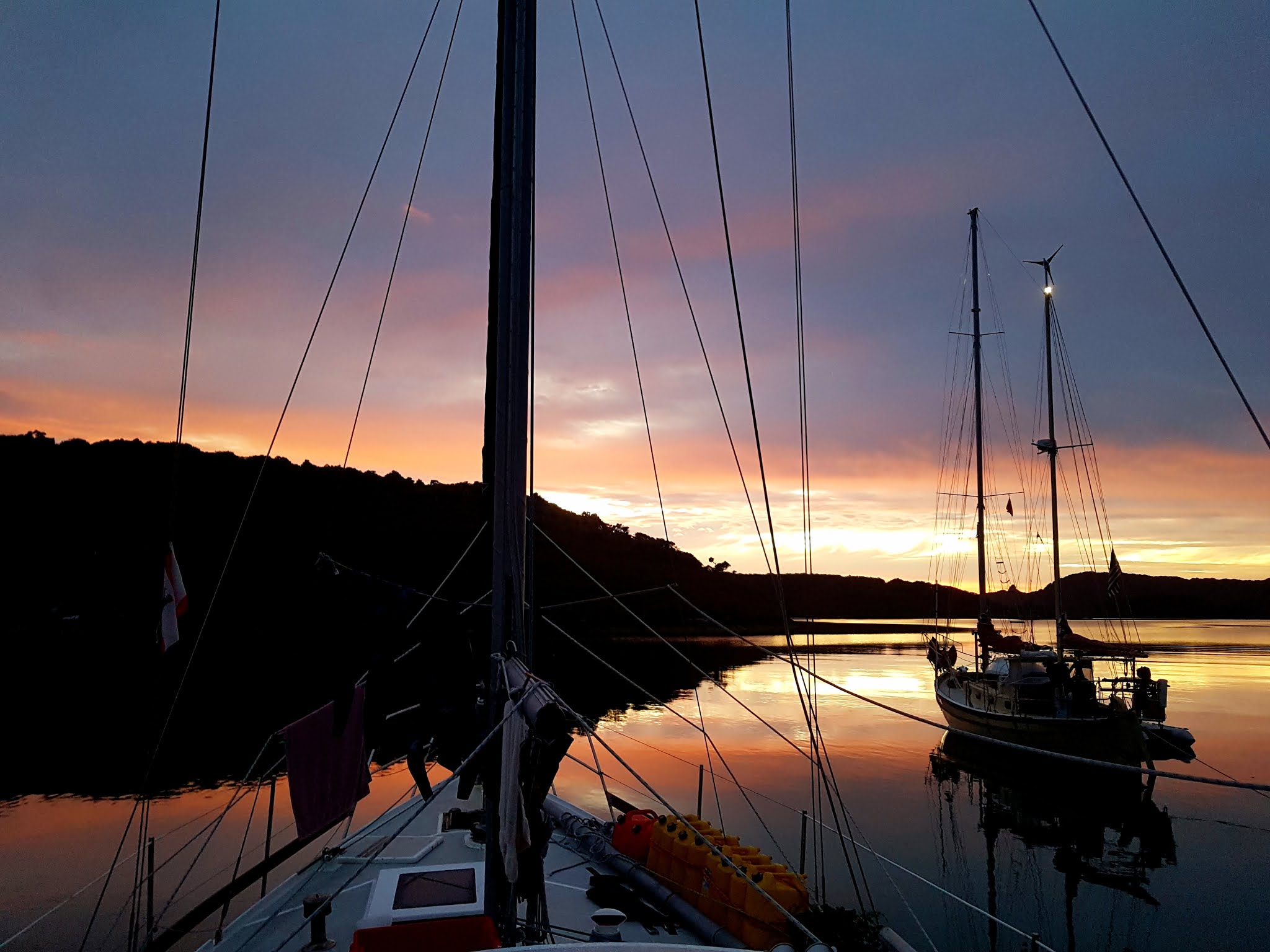
Otago Harbour and the city of Dunedin was our last stop before the jump to Stewart. Having enjoyed our many stops along the way this summer perhaps too much, the season was now well advanced. Finding suitable weather for even short passages down here sometimes requires patience, so as we waited in Dunedin (enjoying every moment!), we wondered if we would actually get to Stewart, and if we did, how much time we would have there. Luck was with us, though, with two days of calm. Once again resorting to the iron wind, we motored on flat water under mostly clear skies to and across the often ill-mannered Foveaux Strait to Oban.

I should mention at this point that, despite the surprising amount of motoring we’ve done on this cruise, we have not actually sought out such conditions. We would much rather sail than motor, but the forecasts were repeatedly either calm winds or, more often, unfavorable ones. It was either motor or wait. But the summer lasts only so long, and we would much rather spend the coming winter at home in Whangarei, so we motored.

Pulling in to Paterson Inlet, we anchored in Golden Bay, just a short walk over a low ridge from Oban. We only spent one night there, but we did so much, it seemed longer. We went ashore a couple of times, checked out the town, the visitor center, the grocery store, refueling possibility, and took a couple of nice walks on well constructed tracks. Next day, we moved a couple of miles to what is known as “The Whalers’ Base.” This was once a place of significant industry. A small community lived there, repairing whaleboats and otherwise servicing the whaling fleet. Now, there are just some old foundations in the bush, and a number of large propellers rusting on the beach. An added bonus was endless mussels on the rocks. 

There were two other boats anchored there, one of them was a sailboat we recognized from back in Whangarei, called Kiwi Logic. We had seen them on the next pontoon from us for several years, but had never met them. Well, now we have, and are sorry we didn’t years ago. Funny how that works — sail a thousand miles away from home to the extreme far end of the country, and only there meet unexpectedly and become friends with neighbors from back home. They had been out diving, and had collected some paua, the New Zealand abalone. Daman made paua fritters for us to try, and sent us home with fresh paua to cook ourselves. We kept intending to try collecting some paua, but the opportunity never presented itself. One came to us, though, clinging to the anchor chain one morning.

Walking Track near Oban
The other boat at anchor there was a sportfisher out on a blokes’ cruise. As we were returning from the beach with a bucket full of mussels, they waved us over, and presented us with a rather large lobster. Barely fit in the biggest pot we have — almost three and a half pounds. Cooked it straight away for lunch. I’d forgotten how good they taste. Robyn had made scones that morning, so as we left the anchorage, she tossed a bag of them to our benefactors. I think I like this place.

We knew that our time down here was limited, and wanted to make the most of it, so we moved most days to see more of the area. After the Whalers’ Base, we visited Ulva Island, a nature reserve inside Paterson Inlet. This is an “open sanctuary,” meaning that, although it is a nature reserve, the public is not excluded as at many other such islands. During the day, the public is free to walk the several well-constructed tracks (which we did), but at night, the island belongs to the birds. You can take a foot ferry over from Oban, or go with one of the tour operators, or you can anchor your yacht in the beautiful Sidney Cove, and just row ashore as you please. It was here in Sidney Cove that we also had our first encounter with the adventure cruise ship Milford Wanderer: the mate motored by one morning in the ship’s tender, “just admiring your boat.”


The tidal currents along the coast here can be quite strong. Even if motoring in a calm, the current could cut our speed by more than half, or shoot us along at warp factor two. And if a strong wind blows across a contrary current, it can raise a wicked sea. Add the shorter days now, and the need to be securely anchored in a new, unfamiliar place well before dark, and you can see how planning our movements was not so straightforward. But the distances between the inlets is not great, and the weather generally cooperated.


Katrin & Daman, Kiwi Logic


Port Adventure, the next such patch of protected water, was only about ten miles south, so we took advantage of more light wind to motor down there. It is not as extensive as Paterson, but it does have several good anchorages. Turning in to the first one, there was Kiwi Logic, so we dropped the hook near them for another visit. Not just keen divers, but also keen  spear fishermen, they provided us once again with some delicious butterfish filets. Robyn has caught the odd fish down here, but we have been much more successful at foraging for mussels, cockles, and pipis (small clams).

Again, wanting to maximize our experience, we spent a night at each of the other two good anchorages in Port Adventure. The first of these, Abraham’s Bosum, is a snug, land-locked cove edged by a beautiful sand beach — like Bali, only in long johns — complete in the morning with a mother sea lion nursing her pup. The third anchorage, Oyster Cove, also a snug spot, no longer has oysters — they were fished out long ago — but we managed to find plentiful large cockles. We also saw the Milford Wanderer again here.


Abraham's Bosum

Mama Sea Lion and Pup


Sea lions were not ubiquitous, but not uncommon either. We often saw one swimming around near us. Much more common were albatross. These majestic birds were a wonder to watch soaring over the waves, seemingly without effort. They appear to defy physics, gliding straight into the wind, wingtips on the water, not flapping their wings at all. Apparently curious, and certainly unafraid, they occasionally settled on the water close by for a good look.


Mollymawk Albatross


Lords River, a drowned estuary, was the next stop heading south towards Port Pegasus, our ultimate goal. The wind was on the nose, and brisk, but only for about ten miles, and there was a three-meter swell, too, also on the nose. But, we figured that if we couldn’t sail a few hours upwind in those conditions, then we didn’t belong down here. Turned out to be a delightful daysail, although I wouldn’t want to sail upwind and upswell like that day after day. And, sure enough, we found Kiwi Logic there again. We weren’t buddy boating, but we certainly enjoyed these times together.


Romping Uphill Sail
This Isn't the Tropics


We had been in contact with American friends on the yacht Banyan, also down from Whangarei cruising these waters. They were on their way north from Port Pegasus, and we had a nice overlap in Lords River for a couple of days. It is customary to tie one’s dinghy up oneself when visiting another yacht. Good thing that’s a habit, cause as I stepped aboard Banyan from our inflatable, somehow the painter had dropped off their cleat and the dinghy was drifting away. Without thinking at all, I launched myself into space, immediately realizing I might get very wet. Even after landing inside the dinghy — which, having an inflatable rubber floor, is much like jumping from a height onto a trampoline — it was still quite uncertain whether I would fall forward, remaining in the dinghy, or backwards, into the water. I fell forward.

We seemed to be on the same itinerary as Milford Wanderer, running into them one last time here in Lords River. This time, we had the opportunity to chat briefly with Mike, the mate, as he was taking guests out on a tour, and also with Annette, the tour director, as she was shepherding a flock of sea kayakers. We invited them over for drinks and a gam later that evening, and spent a very enjoyable time together. These meetings with friends, old or new, on other boats add so much to our cruises.

Port Pegasus is a huge, multi-lobed body of water, separated from the ocean by several passes, and holds many good anchorages. Numerous bold, bald granitic domes and crags create a dramatic landscape, even from a far off approach. This had been the goal all along, and now only some twenty-five miles or so away, we began to think that we might actually make it there. For once, a fair wind offered a pleasant sail. The wind was indeed fair, but a little light, and the huge, lumpy cross swells were tiring, so we were quite happy to gain flat water entering the broad middle pass. The sun was shining, the water glistened, and there was just enough following breeze to waft us along slowly as the dramatic wilderness scenery unfolded all around — the sailor’s equivalent of a hole-in-one, what keeps us coming back. Approaching Evening Cove, our projected anchorage, who should motor up in a dinghy but Daman, from Kiwi Logic! Of course.


Entering Port Pegasus

Quiet Night in Port Pegasus


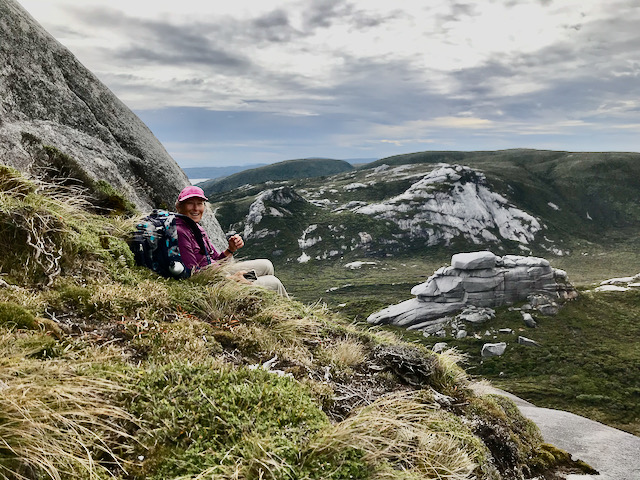
        One of the reasons we chose Stewart Island as our summer goal, rather than Fiordland, is that we really like to go on long walks, and we understood this was likely to be better on Stewart. One of the longest walks down here starts at Evening Cove and follows a supposedly well marked track to the granite peaks Gog and Magog overlooking the west coast. Well, it might have been well marked sometime in the past, but not now. The cruising guide notes that orienteering skills are required. I would raise that to well-developed orienteering skills, and add significant pathfinding skills, too, as requirements. Sections of the track were well trodden, occasionally marked by a ribbon, and easy enough to follow. But these were disjointed, disappearing or marginally discernable, severely testing our pathfinding skills. For a major part of the middle, we simply couldn’t find the track, and had to fall back on orienteering. We could pretty much always see the goal, Magog, in the distance, as the vegetation is mostly low, but getting there devolved into hours of bushwacking — high-stepping on deep, springy ground cover, bashing through dense scrub tree groves (occassionally on hands and knees), picking a way through boggy areas — generally slow and tiring travel. But magic, even so! Traversing this landscape, mostly open with endless views, and with no trace of humanity to the far horizon was cool beyond expression. Eventually intersecting the final section of track, we reached a saddle and the beginning of the final climb up Magog.

The view from that saddle was impressive, down to the west coast not far away, and off in the distant northwest to Puysegur Point, the southwest point of the South Island, some seventy-five miles away. The track up towards the summit of Magog penetrated dense bush, though, with no views either out or up, and gave little choice but to follow the path of least resistance. Finally gaining bare granite above the bush, and scrambling up a few dozen meters, we found ourselves blocked by an exposed section I did not want to challenge. Tired, away from rock climbing for many years, and with the wind howling, we accepted having come close. A brief rest and refreshment, and we started down.

With the section of track below the saddle well trodden, and with ribbons here and there, we were hopeful of finding a better way back. Such was the case for a while, but at the edge of a long marsh, with a ribbon clearly indicating that we were on the track, it just disappeared. Robyn scouted right. I scouted left. We’re both pretty good at this, but we drew a total blank. Back to orienteering — first across the marsh, then avoiding dense scrub thickets, across more marsh, and lastly some open terrain to join the original track near Evening Cove. We both felt our age today.


Bushwacking

One of the Better Marked Sections

Near the Top of Magog

Looking East to Port Pegasus from Magog


A couple of days later, we were considering another, shorter track up a closer granite dome, but that was not to be. I’d been listening to the daily VHF weather forecast, but that only goes out a few days. I’d also been downloading weather files from the SSB radio, but also only looking a few days or so ahead. We expected to be in Port Pegasus for another week maybe before looking for weather to sail back north, so I was only planning short term. Daman had a longer-term forecast, though, that indicated some really snotty weather soon that was likely to pin us down for a week. Realizing that the season was getting late, not wanting to sit hunkered down on the boat for a week, and needing to leave soon after anyway, we decided to bug out. Reluctantly so. Hadn’t been there long enough. Hadn’t done enough. Alas, it was time to head home.


Huddled up to the Heater
(Pays to be Short)

Tuesday, March 9, 2021

Down the East Coast to Dunedin


The forecast was mixed for the next leg of our cruise.  From our anchorage in Port Underwood, our path led southeast out of Cook Strait, around Cape Campbell, and down the east coast of the South Island to Lyttelton, Christchurch’s port.  The promised westerly wind gave us a great run down the Strait, but, also as promised, once south of Cape Campbell, the South Island formed a wind shadow, blocking this wind.  Oh, well.  There are worse things at sea than motoring.  Of course, the wind came up again just as we entered the harbour late the next afternoon — on the nose — giving us an upwind slog into twenty knots or so for the last few miles.  Found a snug spot to anchor, though, caught up on sleep, and motored across the harbour into the new marina the next morning.


Hectors Dolphins, only found in NZ


The new marina took us by surprise; it was only built some three years ago, so was not in the cruising guide.  A very pleasant surprise, though — well protected inside the inner harbour, nice facilities, super friendly and helpful staff, and a short walk to town.

This was all new territory for us, both Lyttelton and nearby Christchurch, so as soon as we were settled in, off we went to explore.  There is a high ridge separating Lyttelton and the harbour from Christchurch.  It is penetrated by an automobile tunnel now, but the early settlers had to walk up and over via a steep track, dragging carts with all their goods.  So, yes, of course, that’s what we did.  Once.  That was enough.  After that, we happily took the bus, especially happy since it’s free for us geezers.

Christchurch is a nice city, but it is as flat as a pancake.  I’m used to seeing at least some hills when I look up, but not here.  It is a nice city, though, with lots of green space, walking areas, museums, etc.  We thoroughly enjoyed a number of excursions there during our six-day stay.  We especially enjoyed spending some time with Sue, one of Caroline Goodison’s sisters.  Carolyn and Ian Goodison are our oldest and dearest friends in Whangarei — pretty much family — and we have always enjoyed meeting their siblings and parents.  Even better was coffee one afternoon with not only Sue, but also Eloise, Carolyn and Ian’s daughter, here for school.

Christchurch has a lot of interesting architecture, both old and new.  Much of the old was damaged or destroyed in the 2011 earthquake, and there is still much evidence of that event.  Massive steel beams hold weakened walls in place, awaiting repair.  The cathedral, an iconic centerpiece in the city, was severely damaged.  Covering the gap where one whole wall fell is a tarp painted to look like the old wall.  Nice touch, that.

Christchurch and Dunedin have a long history with Antarctic exploration; some of the most famous explorers left from here.  Poking around The Arts Centre, a complex of 19th century Gothic Revival-style buildings, originally housing the University of Canterbury, we stumbled upon a very convincing replica of the “James Caird”.  This was the small boat that was central to the survival of Sir Ernest Shackleton and his crew on their ill-fated attempt on the first crossing of Antarctica.


The James Caird (replica)


Victorian Buildings in Christchurch


Sculpture in Central Christchurch


Just east of Lyttelton Harbour is the Banks Peninsula, jutting well out into the Pacific and deeply incised all around with numerous long, sinuous inlets.  The largest of these inlets forms Akaroa Harbour, the site of a French attempt at colonization here in the mid-1800’s.  It’s the oldest town in Canterbury, and one of the most historic towns in New Zealand.  Frank Worsley, the captain of Shackleton’s ship, was born here.  It was also a convenient stop on our way further south.

Refueling was inconvenient in Lyttelton, and the marina manager there had told us that Akaroa had a fuel pump on a floating pontoon, the usual (and convenient) marine arrangement, so we had deferred refueling till Akaroa.  Turned out that the pump there was on a fixed wharf, seriously difficult for a yacht.  You have to tie up to rough wooden pilings, eager to grind up topside paint, and maybe fibreglass, too!  Add in wind and tide, and we don’t want to be there.  Fortunately, there was a floating pontoon on the opposite side of the wharf where we could tie up easily and safely.  A bit too far for the diesel hose, though, so we refueled by jerry jug, our only one, five gallons at a time.

There are only two places to escape weather in the 150 miles between Akaroa and Dunedin.  The first, Timaru, is a small shipping port with no yacht facilities, really only useful to us in an emergency.  The second is Oamaru, a man-made harbour formed by rock breakwaters.  The guide book said the harbour entrance there was heavily silted in, narrow and shallow and only useable at fairly high tide.  Didn’t sound good, but I called the local authorities for current information, learning that the entrance had been dredged the previous year, and was now plenty wide and deep enough at any tide.  So, mostly because we knew nothing about Oamaru, we decided to stop there.  After a disappointing downwind run on a sloppy sea in light wind (lots of uncomfortable rolling with the sails banging side to side), we happily dropped the hook and found an interesting, friendly town.


Oamaru Harbour


Oamaru was an important, wealthy shipping port in the Victorian period, and its beautiful old buildings reflect that.  Many shops also maintain the Victorian theme in clothing and other products.  Most of these old buildings were built with local limestone, a soft rock that lent itself to extensive, intricate carvings.  One example of the friendliness we found there was that we hardly had the anchor down when a local fisherman offered us the use of his mooring in a calmer part of the basin than where we were anchored.  He all but insisted that we use it.


I'd want more than a helmet to really ride this


Better use for a dead tree than firewood.


Nice when the authorities have a sense of humour


Intricate carvings in limestone are ubiquitous in Oamaru


Eager to move on just two days later, we slipped the mooring at first light to motor out, but something was wrong with the engine.  It wouldn’t develop full power, and was blowing a lot of black smoke.  Back to the mooring to check it out.  Turns out we had some kelp tangled on the propeller.  At first I thought I’d have to go for a swim to clear it, but a little revving, shifting back and forth, forward and reverse, chopped it free, so off we went again.

This time the wind was good, gradually building as we approached the entrance to Otago Harbour (Dunedin’s port), such that we came streaming in under reefed main and jib.  The harbour is ten miles or so long, mostly very shallow but with a narrow, sinuous ship channel.  The harbour is huge, wide as well as long, but there is precious little deep enough for a yacht outside the ship channel.  One such spot is the Otago Yacht Club.  They have an enclosed basin with pile moorings and a few floating pontoons, and they are very welcoming to visiting yachties.  We had arranged for a berth there, but we needed to enter at near high tide for adequate depth between the ship channel and the basin.  The land surrounding the harbour forms a venturi, so with the wind and tide behind us, and just a scrap of sail hoisted, we sailed up the harbour doing our best to slow down to let the tide rise a bit more.  Successful at that, we dropped the sail and motored into the yacht club basin.  All we knew was that we were aiming for a downwind landing at a pontoon with 25-30 knots of wind behind us.  I had various contingency plans, but was not happy to see two yachts on either end of the pontoon, both protruding into our approach.  There were many hands, though, waiting to help us moor, so it all turned out fine.  Never any danger, really, just a bit of excitement.  Actually, if no one had been there to help us, we would have just dropped the anchor to stop, and then used warps to pull us in sideways to the pontoon.

Two of the people waiting for us on the pontoon were Murray and Jennie Grimwood.  They had come through Whangarei a few years ago on their return from Tonga.  We saw them again a year or so ago at a wedding of mutual friends up north in the Bay of Islands.  As was the case in Lyttelton, it is so nice to know people when you pull in somewhere.  You don’t feel quite so much the stranger.  Anyway, it doesn’t take long among yachties to make new friends, and here was no different.  Julian and Kara on a neighboring boat had spent a little time in Whangarei just after we left last December, and had become friends with friends of ours there.  We felt part of the community right off.

The yacht club is right at the edge of Dunedin, and we’ve been walking all over, visiting the parks and museums, the farmers market yesterday, a longer walk up to an overlook, etc.  Dunedin also has some interesting architecture.  The old railway station, in particular, is most impressive.  It clearly reflects a time and place that had civic pride (and money to spend on it).  Julian helped me fuel up, providing transport and enough jugs to do the job in one trip.  Murray gave us a tour all around the Otago Peninsula (which forms the south side of the harbour), showing us a number of places not on the tourist maps, then took us home for dinner and a very nice evening.


Stained Glass in the Railway Station


Dunedin Railway Station


Floor of Royal Doulton Tiles in Railway Station


Dunedin Public Art Gallery


From here, it’s about 160 miles to Stewart Island on the south side of Fouveaux Strait.  That’s as far south as you can go and still be in New Zealand.  There are no intermediate harbours between here and Stewart Island, and this is not a stretch of water to treat lightly, so we have been waiting here for a suitable weather forecast.  At this point, Wednesday, it looks good for continuing south this Friday.


Baldwin Street, Dunedin, Steepest Street in the World

Friday, February 12, 2021

Ready to Head Further South

It was a blustery morning here in Hakana Bay inthe upper reaches of Port Underwood (on the South Island side of the Cook Strait).  Each gust pushed us back against the anchor chain, the bow falling off to the side with the boat heeling from the wind.  Then, as the gust passed, she would spring forward from the weight of the chain, standing upright again.  A good morning to be securely anchored, protected from the sea, if not entirely from the wind.  But the gusts faded away about low tide, so we launched the dinghy and went foraging for kai moana (Maori for seafood, but pretty much part of New Zealand English now).  Extensive mussel beds along the rocky shore yielded our daily limit in just a few minutes.  The mudflats nearby provided a bucketful of pipis and cockles.  The only thing better than a snug anchorage is one that provides dinner.


Hakana Bay, Port Underwood

We left the Marlborough Sounds yesterday after just over two weeks between Pelorus Sound and Queen Charlotte Sound, the two making up “The Sounds”.  They are a little different in character, Pelorus being less traveled, and I think a little prettier.  We saw much more recreational traffic in Queen Charlotte, and both more extensive logging and more development in general.  We enjoyed the Sounds, but they are a challenging cruising ground for a yacht; gusty, variable winds mean you have too much sail up one minute, and too little the next.  Deep anchorages lead one to prefer a mooring, but they are not everywhere and the one you want may be taken already.  Visually, the Sounds look a lot like British Columbia.  We did have some good sailing, though, often using just the jib and mizzen, a good combination in gusty conditions — underpowered in the lulls, though enough to keep the boat moving, but not overpowered even in very strong gusts.


Looks a Lot Like British Columbia


Before we left Pelorus Sound, we spent a pleasant few days in Havelock Marina.  Did the washing (laundry), etc.  Steven and Maggie drove over from Nelson for a hike, and then lunch at the “Mussel Pot”— best mussels I’ve ever had.  Havelock is pretty small, though, so when we looked for a nice restaurant to celebrate our 33rd wedding anniversary, we wound up with steaks from the little grocery instead, to grill on the boat.


A few days after leaving Havelock, we motored around Cape Jackson into Queen Charlotte Sound on flat, glassy water.  Sailing might not be so great here, but the fishing isn’t bad.  The day before, Robyn pulled in a snapper, a kahawai, a barracuda, and a blue cod.  After entering Queen Charlotte, we stopped to drift and bottom fish a bit, and Robyn quickly landed three gurnards.  Gurnards are strange looking fish, with enormous pectoral fins like butterfly wings, and what appear to be three pair of legs!  Strange looking, but super tasty.


Nasty Teeth on a Barracuda


Ever See Legs on a Fish?


We knew that our German yachtie friends, Dietmar and Marie, were somewhere in Queen Charlotte Sound.  We also knew that the motor vessel “Starlet” was in the area.  Her owners, Mark and Jennifer, who we know from Whangarei, were on their way back north after visiting Stewart Island (i.e. our destination).  They are also international visitors “stuck” here in the pandemic.  Shortly after our gurnard lunch, we re-entered cellular coverage and got a text from Marie that they were on a mooring quite near where Starlet was anchored, and did we want to join them all for dinner.  Clearly yes, so a few hours later, we rafted up to Greyhound again, after which we all enjoyed a wonderful evening and delicious dinner on Starlet.


Whangarei Wanderers on M/V Starlet


Dietmar and Marie had raved about their visit to Lochmara Lodge not far away, so still looking for that anniversary dinner, we decided to give it a try.  After a few hours of mixed motoring and the typically gusty sailing, we happily picked up one of their moorings.  Cleaned up and hungry, we signaled for our waiter to ferry us ashore — classy place, this!  We were not disappointed.  We do not dine in such posh places often, but once in a great while, it’s really nice.


Awesome Cheesecake at Lochmara Lodge


Then it was in to the marina in Waikawa for groceries, water, etc. — the usual — before leaving the Sounds enroute to Lyttelton Harbour and Christchurch.  I must confess to a little trepidation about exiting Tory Channel into Cook Strait.  The currents here are vicious, with not much slack between ebb and flood, and Cook Strait has quite a reputation.  Weather forecasting here is quite good, but topographic effects are significant, making it hard to know exactly what to expect at a specific place.  Once heading out, there would be no turning back against the current.  Well, silly me, we motored through on flat water into the equally flat Cook Strait.


Exit from the Sounds into Cook Strait


Didn’t stay that way long, though.  Forecast rising wind motivated us to hustle along the fifteen miles or so to Port Underwood.  Powerful gusts soon came off the dramatic shore as we motored along.  Every time a lull made me think about raising sail, another gust laid us over.  Close to shore, though, the seas were merely a little choppy.  Happily for us, Hakana Bay turned out to be an excellent place to wait for good weather to continue out of Cook Strait and down the east coast.  The forecast looks promising for us to depart here early Sunday morning, expecting to arrive in Lyttelton Monday afternoon.  We’ll see.  Stay tuned.